Pittsfield names 'Cadwell Woods Conservation Area'

PITTSFIELD, Mass. — The so-called Saw Mill property has a new name that honors its origins as a family farm.
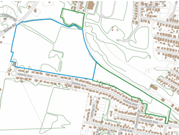
On Thursday, the Conservation Commission voted to rename the more than 50-acre parcel "Cadwell's Woods Conservation Area." The property dates back to the Cadwell family years before Pittsfield was founded and remained with them for 175 years.
In the early 1900s, it was referred to as the "Cadwell's Woods."
Last year, the city acquired the conservation land along the southwest branch of the Housatonic River to permanently protect it from development. It can be used for passive recreation such as bird watching, hiking, fishing, and other activities that have a mundane impact.
The property consists of three parcels totaling 52.3 acres with 1/4 mile of frontage on the Housatonic River. They are bound by Barker Road and Velma Avenue to the south and to the east by railroad tracks and Industrial Drive. There is also a small portion on the north side of the river at the end of McKinley Terrace.
Within the acreage are areas of core habitat mapped by the state's Natural Heritage and Endangered Species Program.
Commissioner Thomas Sakshaug said he likes Cadwell's Woods out of the list of possible names and other members agreed, adding that "conservation area" should be added to the name to clarify its use.
"I do think it's helpful on the sign level because that's what informs the public who will be going there what this area is," Commissioner Jonathan Lothrop said.
"So I do agree that the conservation area should be on there so that people have some idea that it's a city property effectively for the public's enjoyment."
The "Home Historian" Joe Durwin prepared a historical document for the property that details its origins from the 1700s to modern times. It was the northern portion of a larger plot granted to Westfield's Abel Cadwell by King George in 1748 and extended south to near the base of South Mountain.
"According to Cadwell family history, Abel sent his son Dan and Nathaniel Fairfield to investigate his new land in 1749, three years before the first settlers built in what is now Pittsfield, and they spent the first night sleeping in a hollow log. While there, they are said to have seen a group of
indigenous people but did not interact with them," Durwin reported.
"A year later, Dan's brother Timothy purchased more lots in south Pittsfield (then "Pontoosuck Plantation"). In 1758, Dan first built a log cabin on the north side of South Mountain Road, and Timothy built on the south side of the road. They brought with them from apple seeds which were planted nearby, where they were used in cider making from the late 1700s to the mid-20th century at the Howard cider mill. (descendants of the Cadwell apple trees can still be seen around South Mountain Road, in the area of Eaton Lane)."
The farm came to have three Cadwell houses on it and was owned by descendants until 1991.
Around the turn of the 20th century, the former Pittsfield Sun and The Berkshire Eagle referenced the northern area of the property as "Cadwell's Woods."
In the 1920s, portions of the farm were sold to Cecil Gamwell, who expanded development in from Cole Avenue and Spadina Parkway. The parcels were sold to Samuel Monterosso around 1950 after Cecil's death and he developed Gamwell Avenue and the eastern half of Velma Avenue across the former Cadwell property.
Monterosso sold the remainder of the former Cadwell land to Lipton Realty around 10 years later and a large apartment building proposal was denied due to neighborhood opposition in 1960.
"Instead, the Lipton family developed single-family homes gradually west into the Cadwell parcel over the next two decades, including Jeffrey Lane and all the western half of Velma Avenue, with the last house built in the 1980s," Durwin reported.
"In 1986, Lipton Realty sells the remaining undeveloped Cadwell land to Kermit & Miriam Goodman of Dillon Nominee Realty Trust, who then transfer it into the Saw Mill Nominee Trust."
Over the past century, the land has been used recreationally and sometimes as a refuge for those without homes, with reports of campers dating back to the late 1970s.
The city has been working toward purchasing this property since 2007 when it received funding but could not come to an agreement with the ownership group, Saw Mill School Nominee Realty Trust. Instead, the funds were utilized to purchase Barkerville property on Barker Road.
The 50 acres of conservation land along the southwest branch of the Housatonic River was purchased last year for $400,000.
The cost was covered using grant and city funding. The city was awarded a $280,000 Local Acquisitions for Natural Diversity grant from the state's Executive Office of Energy and Environmental Affairs.
The remaining amount was covered using $20,000 of the city's capital funds, $50,000 from the Conservation Commission, and $50,000, from Pittsfield's Community Preservation Act.
Tags: conservation & recreation, conserved land,


