Long abandoned Keystone Arches get trail

By Anthony FydenPrint Story | Email Story
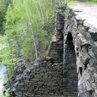
A new trail showcasing the stunning Keystone Arches, along the Westfield River, will open later this month. The bridges made of massive blocks of stone helped the railroad push westward. ( Photo By Anthony Fyden)
CHESTER — A new hiking trail is set to open in western Massachusetts — a trail that showcases the stunning beauty of the Berkshire Hills, the history and romance of the early railroad and the engineering marvel that is the Keystone Arches. A dedication ceremony will take place on May 22 with a daylong celebration on the grounds of the new Chester Elementary School, about one mile from the trailhead. There will be a ribbon cutting, but this is a trail dedication, so the event will also feature kayaking, fly-fishing demonstrations and treks along the trail. Berkshire residents, even those who have lived in the region their whole lifetimes, may be wondering why they’ve never heard of the Keystone Arches. It’s not surprising. The arches have been pretty well hidden for much of this century, not accessible by any trail. Those who did make their way through the bramble to see the stone marvels were trespassing. “The arches really are phenomenal,” said Christopher Curtis, principal planner for the Pioneer Valley Planning Commission. “They’re historical and scenic assets to the region, quite extraordinary, very beautiful and interesting as a destination for hikers or people interested in the railroad industry.” What are the arches? They’re stone railroad bridges that date back to the period when the railway was forging west to America’s frontier. Boston traders wanted to expand their markets to Albany, N.Y., and beyond, but engineers took one look at the mountains, valleys and rivers of the Berkshires and decided that building a railroad line there would be next to impossible. Major George Washington Whistler didn’t think so. He meticulously surveyed the region and came up with a plan. The railway line would follow the Westfield River, which offered the lowest altitude for crossing the Berkshire range. But it wouldn’t be an easy route. The twists and turns of the river would mean almost constant bridging. In the end, 27 bridges were built, including the 10 massive keystone arches — the first keystone arch bridges built in America, the highest of which towers 70 feet over a gorge. The arches, using technology that dates back to the ancient Greeks and Roman, are remarkably durable. The massive blocks were set in place one-by-one, with no mortar needed. Two are still in service after nearly 100 years bearing even more weight than they were designed for. As the transportation system evolved over the years, however, most of the bridges were abandoned, left to the elements and marred by vandals. The only way to catch a glimpse of the dramatic arches until a few years ago was to trespass on railroad property or walk along the tracks, illegal and often very dangerous. About 10 years ago, an effort was made to improve access, build a trail and restore the bridges, overseen by the Pioneer Valley Planning Commission. The Friends of the Keystone Arches group was formed, led by David Pierce, an employee at Gateway Regional and a longtime admirer of the area. “I discovered the arches back in the 60s, hiking with a friend of mine,” Pierce recalls. “I just thought it was an amazing place. Everyone I brought there after that just fell in love with it.” The concept of forming a Friends group and developing the area evolved over time, he added. Things looked promising for the development after the Pioneer Valley Planning Commission took over the project, with some grant money supposedly on the way to help. A team of AmeriCorps workers spent time over two summers at the site. But – after much of the planning had been completed – the project stalled when the money never materialized. After a frustrating wait, Pierce and others chose to take matters into their own hands. “We finally had a plan in place,” Pierce recalls, “and we decided we could do a lot of this stuff ourselves.” Pierce credits students from Gateway Regional High School for their hard work at the site. Gateway teacher Joseph Charnley, a member of the Friends group, incorporated work on the trail with the school’s outdoor activities plan, and many students helped out. Through the work of these volunteers, the project forged ahead. The trail now traverses three towns, Becket, Chester and Middlefield, in three counties, Berkshire, Hampden and Hampshire. Tons of brush and debris have been removed, creating a scenic hike along with river, with the archways as waypoints. Over the decades, Curtis said, the arches have suffered due to time and vandalism. Most of the graffiti and other vandalism has been cleaned up, and some damage has been repaired, at least to prevent further deterioration from occurring, he said. The trail itself is about 2.5 miles long, although there are several side trails available for those who want to make a day of hiking in the area. The terrain is moderate along the trail, with some rocky and low-lying wet areas. While the trail itself will likely be popular with outdoor recreators, railroad enthusiasts and historians, the dedication marks only the first phase. “We hope that the next major step, and it’s the most costly part of this, is the restoration of the bridges,” Curtis said. He added that grant funds have been dedicated for the project, and MassHighway recently advertised for a construction contractor. “It does look very promising at this point,” Curtis said. A number of groups are looking forward to using the trail, both for its historic and recreational features. Many of these groups may participate in the opening celebration, according to the Friends’ Web site. Activities may include stone cutting and railway worker re-enactors from Storrytown Village, a blacksmith from Hancock Shaker Village and the Mass 10th Civil War living history exhibit. The state Division of Fisheries & Wildlife Fish will offer demonstrations and information. The Berkshire Scenic Railway Museum, Wild & Scenic Advisory Committee, Chester Gardeners, Gateway High and Middle Schools environmental and Salmon fry projects, crafters and the Chester Miniature Theatre are also scheduled to participate. A special postal cancellation will honor the 100-year partnership between the railroads and the U.S. Postal Service. The Chester Hill Winery — wine was one of the products that spurred the railway’s development — has marked the opening of the trail with a commemorative-label blueberry wine. Pierce hopes that the dedication is well attended, by both residents and by local officials. His reasoning is that once people see the area, many will be willing to help complete the project. “That’s kind of the underlying purpose of this,” he said. “We’d like to see as many people there as possible.” The ribbon cutting will take place at 1 p.m., with a number of local and state officials expected to be on hand. Information: Friends of the Keystone Arches, 354-7752. Visiting the Keystone Arches Trail By Anthony Fyden The Keystone Arches trailhead can be found by traveling on Rte. 8, through Becket and into the town of Chester. In the center of town, take a left onto Middlefield Rd. The trailhead will be found on the left, about 2.5 miles down the road. There is no sign at this point, just a gravel parking area. The trail begins as a gravel path, crosses over a bridge, with a small waterfall to the right and the Westfield River to the left. The Keystone Arches is a recreational area developed mostly through the hard work of volunteers, so it’s not as polished as some areas, but that adds to its rustic appeal. The volunteers have built some informational kiosks and painted blue blazes to help people keep to the trail. Good hiking or walking shoes are definitely needed. After a short distance, the trail meanders into the woods for a time, as a footpath. There are numerous spots to access the river for fishing. Visitors will probably see or hear some trains pass nearby, both passenger and freight trains. Although the Arches trail covers 2.5 miles, with mostly easy walking, there are numerous opportunities to explore side trails, some offering challenging steep and rock grades. This reporter walked for more than six miles on a Tuesday evening visit, without coming close to fully exploring the area – and, incidentally, spotting no other hikers. The site is quiet, with the tar-scent of railroad sometimes wafting pleasantly on the wind, mixing with the fresh air of woods, mountains and river. After traversing a small stream by hopping a few rocks and then returning to a wider trail – a bridge is scheduled to be built this summer – the first of the arches is visible. After catching a glimpse of the first arch, visitors can walk out on top of the structure. Most of the arches can be walked on, in fact. The first arch offers an outstanding view, from both sides, with mountains all around, the river about 60 feet below. The arches themselves are something to see, medieval-looking bridges made of massive blocks of stone. There are no guardrails on top of the arches, which adds to the awe-inspiring experience. Parents should keep a close eye on kids, however. The arch bridges tower 50-75 feet over the river, with many rocks below. The bridges can sneak up on hikers, so it’s a good idea not to allow young children to run too far ahead. There are active railroad tracks nearby as well, and it is illegal and dangerous to walk on them. The Friends of the Keystone Arches cite the area’s natural beauty, historical significance and the appeal of the stunning Arches themselves. It takes a visit to the site, though, to truly get a sense of the Arches Trail, which may well become a popular destination.
If you would like to contribute information on this article, contact us at info@iberkshires.com.

Lanesborough Fifth-Graders Win Snowplow Name Contest

LANESBOROUGH, Mass. — One of the snowplows for Highway District 1 has a new name: "The Blizzard Boss."
 
The name comes from teacher Gina Wagner's fifth-grade class at Lanesborough Elementary School. 
 
The state Department of Transportation announced the winners of the fourth annual "Name A Snowplow" contest on Monday. 
 
The department received entries from public elementary and middle school classrooms across the commonwealth to name the 12 MassDOT snowplows that will be in service during the 2025/2026 winter season. 
 
The purpose of the contest is to celebrate the snow and ice season and to recognize the hard work and dedication shown by public works employees and contractors during winter operations. 
 
"Thank you to all of the students who participated. Your creativity allows us to highlight to all, the importance of the work performed by our workforce," said  interim MassDOT Secretary Phil Eng.  
 
"Our workforce takes pride as they clear snow and ice, keeping our roads safe during adverse weather events for all that need to travel. ?To our contest winners and participants, know that you have added some fun to the serious take of operating plows. ?I'm proud of the skill and dedication from our crews and thank the public of the shared responsibility to slow down, give plows space and put safety first every time there is a winter weather event."
 
View Full Story

More Stories